


Please enter the answer below before you can view the full text.
5-3=
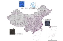
Land cover products are the main products among remote sensing satellite products, presenting the state and changes of the earth's surface and serving global environment and regional sustainable development. However, affected by factors such as different image data sources, classification techniques and production environments, the product accuracy shows great differences in practical applications, which are reflected in product varieties, specifications, quality, scale and timeliness, resulting in huge challenges in the authenticity verification of land cover products in practical applications. In this paper, aiming at the aerospace remote sensing application mode of "standarization for satellites design and it's optimal applications", a land cover product verification method based on ground control DS of classification is proposed. Starting from the requirements for verification samples in terms of quantity, quality, and distribution, it constructs credible classified control parties with controllable distribution, quantity, and quality, optimizes the verification process, and realizes truth-value verification for land cover products produced from different satellite data. By optimizing the verification process, a new approach is provided for the authenticity verification of large-scale land cover products.
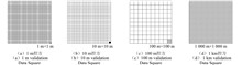
Under the background of high-quality development of China's satellite remote sensing technology, the multi-source satellite soil moisture products in the "standarization for satellites design and it's optimal applications" space engineering application face challenges such as inconsistent product specifications and limited collaborative application due to algorithm differences, sensor performance, and surface complexity. To address this core issue, this article takes the construction of a standardized and strictly quality-controlled soil moisture standard quantitative product (SSMP) as the core goal. It breaks through the traditional single-satellite verification mode and innovatively builds a standardized, multi-level soil moisture control system. It also proposes a large-scale accuracy verification process for SSMP based on the control system. This system provides an expandable standardized production framework and a systematic quality inspection path for multi-source satellite soil moisture products. It not only lays a methodological foundation for the subsequent large-scale collaborative application and integrated analysis of remote sensing soil moisture products, but also offers important theoretical support and practical reference for further enhancing the engineering application efficiency of multi-source satellite remote sensing data in fields such as agriculture, hydrology, and meteorology.